By Nico Ventura and Carmelo Ignaccolo
At the end of World War II, Venice had almost 175,000 inhabitants. The post-war population was numerically quite close to the city’s historical maximum of 190,000 people reached in 1570. Even in the 16th century, the population “included a large number of poor people”, who were decimated by the 1575-77 plague (Lane,1973). While housing conditions were perhaps still tolerable during WWII, the post-war peace and promises of economic development made the housing stock become obsolete from both building standards and hygiene perspectives (especially ground-level residential units located in narrow streets and flood-prone areas).
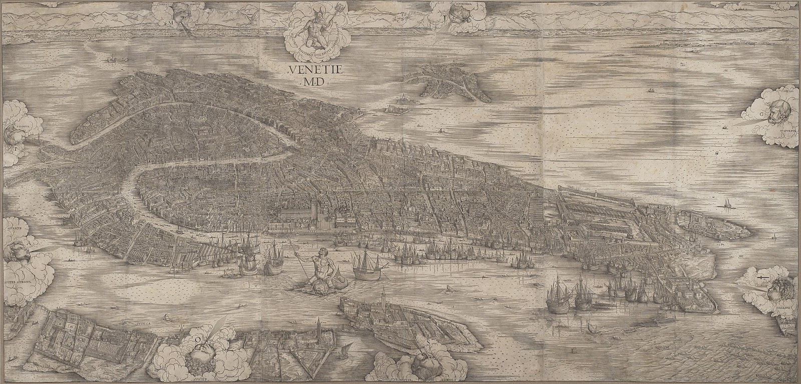
View of Venice (1500) by Jacopo de’ Barbari, Minneapolis Institute of Art
The challenges triggered by housing obsolescence were not new to Venice. However, during the glorious time of the Serenissima, the precarious conditions of its city fabric were pretty much confined to the marginal areas within the insulae of the city fabric. The Serenissima was an isotropic city without walls and doors (Ventura, 1985). The city worked in perfect osmosis with the lagoon through an intricate system of canals, fondamenta (walking bank along the canals), calli (narrow pedestrian alleyways), and campi (city squares) belonging to a wider network of “insulae” with equal hierarchical statuses. As a testimony of the rich variety in the city fabric, Venice developed its very own street-type naming convention: from salizada (a stone-paved street) to ramo (a short and narrow subdivision of a calle), and to ruga (simply an important street). The plethora of street naming conventions is mirrored in the water-channels (canele, rio, piscina, paludo) and in the building types (palazzo, ca’, portico). Most buildings belonging to either aristocrats or wealthy merchants belong to the “passante” typology: a building that faces both water and street navigation networks. Homeowners used to receive goods at the water-gate of their buildings, where the ground floor was mostly designated for storage space. Domestic workers used to live in the low-ceiling top floor rooms, whereas noble families used to inhabit first-floor apartments, often equipped with large windows and balconies.
While the aristocrats, merchants, and city officials used to hold their daily activities mainly in the neighborhoods of San Marco and Rialto, the rest of the city’s population enjoyed flocking to these areas for feasts and celebrations. Even the San Marco Basin reproduced a specific urban layout on its own: the seat of power, the Palazzo Ducale, was at the same time adjacent to the prisons and not far from the State Mint and the granaries (demolished in 1808 by the order of Napoleon), which were in turn opposite to the salt warehouses.
Venice’s isotropy, fueled by myths (Venice was born from the waters in an unusual union between Venus and the Virgin Mary), was abruptly terminated by the construction of the railway bridge. This infrastructure connected the lagoon islands to the mainland. Beyond the most extravagant hypotheses that initially wanted the railway station in the basin of San Marco, the criterion of the minimum distance to the mainland was preferred: the station was built in the area of Santa Lucia (1865), on the western edges of the city.


G. Biondetti Crovato, Idea per una nuova strada ferrata, 1867 (left); Design proposal for Santa Lucia (right).
With the construction of the railway station, the city changed its original mobility patterns. The Grand Canal, in fact, used to work as a crossing line ( al di là dell’acqua, “here and there of the water”), but, with the construction of the railways station, it started operating in an axial direction: from the station to San Marco. When the Kingdom of Italy took over the city (1870), a land-based development model guided some demolitions to make space for the Strada Nova: a pedestrian axis more or less parallel to the Grand Canal. The demolitions included a series of “targeted” interventions that are similar to other projects à la Haussmann happening in Italy and Europe in the late 19th century.


Design proposal for the “Strada Nuova” (left); Miozzi, ponte Littorio, 1932 (right).
In those years, two new bridges were added along the Grand Canal: the first one is the iron bridge named Ponte dell’Accademia, near the southern end of the canal (Neville, 1854) – later (1933) demolished and replaced by a wooden “temporary” bridge that is still in place; the second one is an Istrian stone bridge, close to the railway station (Miozzi, 1934). At the same time, the last canal port on the island of Giudecca and related maritime industries gradually lost their prominence because of the rising “Marittima”: two large piers connected to the railway yard (1869). Finally, when the cross-lagoon bridge doubled its road surface and the tabula rasa of Piazzale Roma was made ready to welcome vehicles (1933), residents witnessed the definitive affirmation of the “bridgehead area” (Ventura, 1985). These infrastructural changes inevitably disfigured the original forma urbis represented by Jacopo de Barbari in 1500.
Giuseppe Samonà in his “Novissime” project (1964) tried to reimagine a city without the cross-lagoon bridge by suggesting a light-rail connection to mainland instead of a car-oriented bridge. His utopian idea remained unheard.


Giuseppe Samonà and collaborators, Project for the Tronchetto Island (competition submission), Trincanato 3. Attività professionale/1/049, Archivio Progetti Iuav, Venice (left); L. Quaroni, Concorso CEP per Campalto, Venezia 1959 (right)
From an urban fabric standpoint, a city that used to be double-sided in its banks, in its calli, and in its buildings mutually exposed to water and land, became unrecognizable to the Venetians themselves: accustomed to a “pedestrian” view they struggled to recognize their own places from the calli. Unsurprisingly, the pedestrianization projects that buried some canals (turning them in rio terrà), built more bridges and widened some fondamenta, contributed to an overall urban impoverishment of the typical water-based Venetian navigation system.


Ponte Rio di San Maurizio (left); Rio della Fornasa (center); Rio Tera’ Foscarini (right)
Similarly, the larger lagoon islands system has been slowly deprived of its atavistic relations with the city that generated it. The islands, in turn, began manifesting the crisis of a peripheral network in economic decline. This included, among others, the glass processing industries of Murano. The smaller islands with monasteries and hospices were left empty in the hope of attracting some tourists. The island of Lido embraced a development model similar to a car-oriented residential suburb. And the large industries – originally relocated to Marghera before WWII – were then moved to the second industrial zone of Mestre and to a planned third area. Eventually, the latter will not even be developed: hydraulic engineers verified that the pumping system would have produced risky land subsidence effects.
In the midst of the second half of the 20th century, Venice lost inhabitants and acquired commuters working in the tertiary sector. Mestre, which had been a village-size settlement close to a docking port on the mainland for a long time, attracted thousands of residents thanks to a very appealing price/quality ratio for housing and to the promise of being “freer on a car than on a boat”. Mestre recorded more than 200,000 inhabitants in 1971.
The Venice Town Plan was approved in 1962 when building speculation had been working for 10 years in Mestre and the Lido. Mestre’s development trajectories pointed towards the hinterland and did not overlook the lagoon, with the exception of Campalto (a historic village on the edge of the lagoon). During the competition organized by the local authorities (1958), there was a heated debate between Quaroni’s innovative ideas and Muratori’s traditional urban-form approaches. Muratori won the competition, which, however, did not evolve into an executive action plan. In fact, city planning authorities carried the project along without any guidance from prominent architecture figures of that time.
In regards to the historic center, a rigorous conservation approach prevailed over several new design projects. In general, neither Wright (Cà Masieri, 1952), nor Le Corbusier (Hospital of Venice, 1964), nor Luis Khan (Palazzo dei Congressi, 1972) succeeded in leaving their marks on the urban fabric of Venice.


F.L.Wright, Project for Cà Masieri, 1959 (left); Le Corbusier, Venice Hospital, 1966 (center); Luis I. Kahn, Project for Convention Center, 1974 (right)
After all, the architectural historians from IUAV such as Zevi, Tafuri, and Concina and the urban planners, such as Astengo, Trincanato, and De Carlo promoted the very same conservational attitude. Albeit with different focuses, we can still record some modern interventions both in terms of housing solutions and suburban development plans (Valle in 1986, Gregotti in 1987, De Carlo in 1997).


Valle and collaborators, residential settlement on Giudecca, 1986 (left); Gregotti Associati, residential settlement on area San Giobbe, 1987 (right)
However, the notion of “modernity” has had a hard time to be successfully executed in the hybrid land-water system of Venice. Perhaps only Siza’s sketches can be considered among the rare convincing efforts of envisioning a new type of autochtonous Venetian modernity.


Á. Siza Veira, Sketches for Terminal of Tre Porti, 1981.
Alongside the design debate, COSES (Consorzio per la Ricerca e la Formazione) carried out a significant research effort to address the socio-economic challenges of the city in regards to the tourism industry. However, COSES delegated the responsibility of defining the standards for a sustainable tourism model to Ca’ Foscari Professors E. Canestrelli and P. Costa (1988), who established the tourism capacity of the city as a “one tourist per permanent resident” rule.
Towards the end of the ’90s, Venice had approximately 70,000 inhabitants. At that time, a national legislation act liberalized hotel licenses and authorized the transformation of residential housing types into tourist residences. While some public services such as the outdoor market and the Court tend to remain in the historic center by moving their locations in the proximity of the cross-lagoon bridge, the privately-owned facilities tend to move to the mainland. For example, the Assicurazioni Generali left the historic headquarters in Piazza San Marco in 2013. A few years later, the port – now only a passenger maritime station – opened to “large ships”. Since then, public-funded interventions remain focused on transportation: a people mover connects the Tronchetto (a third island alongside the Marittima, mainly used for parking) to the maritime station and to Piazzale Roma; a jumbo tram runs on the cross-lagoon bridge towards Mestre; new piers were built in San Marco and Lido; and the new Constitution Bridge designed by Calatrava in 2008 crosses the Grand Canal, connecting Piazzale Roma to the railway station and from there to the Strada Nova. By advancing these plans, the “bridgehead” has gained a continuously growing centrality in the city. Other ideas in support of a decentralized access system through the three terminals of Fusina, Tessera, and Tre Porti were disregarded in favor of the main transit hub of Piazzale Roma.
Despite these radical changes, Venice – or at least part of it – has shown unexpected resilience to transformations that have substantially altered its physical fabric. This is particularly true for the residential housing stock that has been rapidly yet dangerously transformed into short term accommodation units for visitors. While according to Jan Van Der Borg the tourist capacity should be limited to 52,000 visitors per day (equal to 19 million per year), some studies reported more than 30 million in 2018. The peak achieved in 2018 was not equaled in 2019 because of the November flood and in 2020 because of the global health emergency. Today researchers are proposing to overcome the residential crisis of the historic center with longer stays both to limit the effects of the infection and to fuel a new integration model between residents and visitors. In the midst of the current debate, academic institutions, public authorities, and international agencies have been working for some time to propose alternatives: from limited pre-booked entrance tickets to the lagoon to cruise ship bans. In addition to these tourism management proposals, some drastic governance changes are often demanded by locals and international agencies such as the creation of an international protectorate for Venice. Unsurprisingly, these changes have been ignored alongside the referendums that since 1979 periodically relaunch the administrative division between Mestre and the historic center.
Perhaps those same national and international institutions could promote research centers on pollution, tides, climate change, but also on conservation and restoration. Venice as a laboratory for the future of our cities, challenged by humans and natural events: if not now when?
Nico Ventura is a Professor of Industrial Design at Politecnico di Milano and Art Director of the Venice based design firm HereArchitecture
Carmelo Ignaccolo is a Ph.D. Candidate in City Design and Development at MIT, DUSP, and an Adj. Assistant Professor at Columbia University GSAPP.
References:
Canestrelli E., Costa P. (1991), “Tourist carrying capacity: A fuzzy approach,” Annals of Tourism Research, Volume 18, Issue 2
Dorigo W.,(1985), “Toponomastica urbana nella formazione della città medioevale,” in Rassegna n. 22 – Venice, City of the Modern
Lane F.C. (1973), Venice, a maritime republic, Johns Hopkins University Press
Ratti C. (2020), “Così un nuovo turismo salverà Venezia dalla crisi.” Il Corriere della Sera
Tafuri M. (1985), Venice and the Renaissance, Einaudi, Turin
Van der Borg J., D. Bertocchi D. (2018), “ La capacità di carico di tipo turistico di Venezia nel 2018” in CfNews
Ventura N. (1985), “L’acqua come opportunità”, in Rassegna n. 22 – Venice, City of the Modern